
Really, there’s no “perfect” way to walk across America. Which route you will want to take depends entirely on timing, resources, and personal preference.
But if you want to walk across America while utilizing the highest percentage of trails? This is your gal.
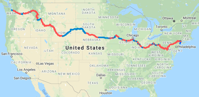
It’s approximately:
~4094 miles
69% trail, 31% roadway
Red=trails, Blue=roadways
It passes through 13 states and is compromised of over 40+ trails, including (but not limited to):
The Appalachian Trail, C&O Canal, Great Allegheny Passage, Panhandle Trail, Montour Trail, Conotton Creek Trail, Ohio to Erie Trail, Great Miami River Trail, Wolf Creek Trail, Cardinal Greenway, Converse Junction Trail, Nickel Plate Trail, North Judson Trail, Erie Lackawanna Trail, Old Plank Road Trail, Illinois & Michigan Canal State Park Trail, Hennepin Canal Parkway, Great River Trail, Cedar Valley Nature Trail, US 30-Trail, Heart of Iowa Nature Trail, Raccoon River Valley Trail, Cowboy Recreation Trail, Continental Divide Trail, Idaho Centennial Trail, Coeur d’Alene Trail, John Wayne Pioneer Trail, Palouse to Cascades State Park Trail
—
This route is essentially the Great American Rail Trail if it started in New York City, and all the gaps between existing sections of the Great American Rail Trail were filled in with back roads and other neighboring trails.
The Great American Rail Trail (aka my newest obsession): a proposed long-distance trail by the Rails-to-Trails Conservancy (RTC) that, when completed, will span the entire length of the country/continent, from D.C. to the coast of Washington state. As of 2020, it’s only 52% completed. And, despite millions raised in funding last year, it’s unlikely to be finished for a few decades.
Want more information on the Great American Rail Trail? Check out their website: CLICK HERE
My route may not be the fastest, nor the simplest, way to walk across America. But it’ll get you there.

New York/New Jersey
Total mileage ~ 166.84 miles
Miles of Trail ~141.39 | Miles of Roadway ~25.45
85% trail, 15% roadway
Roadway Gap ~15.2 miles (mostly sidewalk)
North County Trailway ~23.2 miles
Roadway Gap ~4.66 miles
Briarcliff Peekskill Trailway-Miscellaneous Trails ~8.99 miles
Roadway Gap ~5.59 miles
Appalachian Trail ~109.2 miles

Pennsylvania
Total mileage ~ 394 miles
Miles of Trail ~382 | Miles of Roadway ~12
97% trail, 3% roadway
Appalachian Trail ~222 miles
Great Allegheny Passage ~127 miles
Pittsburgh Road Gap ~12 miles
Panhandle Trail-Montour Trail ~33 miles
~45 miles

Maryland
Total mileage ~ 184 miles
Miles of Trail ~184 | Miles of Roadway ~0
100% trail, 0% roadway
Appalachian Trail ~39 miles
C&O Canal ~124 miles
Great Allegheny Passage ~21 miles

West Virginia/Ohio
Total mileage ~ 329.77 miles
Miles of Trail ~227.66 | Miles of Roadway ~102.11
69% trail, 31% roadway
Panhandle Trail ~2 miles
Roadway Gap ~31.1 miles
Conotton Creek Trail ~11.2 miles
Roadway Gap ~ 21.15 miles
Zoar Valley Trail ~20.1
Ohio To Erie Trail ~11.1
Roadway Gap ~15.5 miles
Ohio To Erie Trail ~15.8 miles
Roadway Gap ~8.21 miles
Ohio To Erie Trail ~124.8 miles
Great Miami River Trail-Mad River Trail-Creekside Trail ~32.3 miles
Wolf Creek Trail ~3.36 miles
Roadway Gap ~3.45 miles
Wolf Creek Trail ~7 miles
Roadway Gap ~22.7 miles

Indiana
Total mileage ~ 232.08 miles
Miles of Trail ~115.19 | Miles of Roadway ~116.89
49.6% trail, 50.3% roadway
Roadway Gap ~5 miles
Cardinal Greenway ~50.7 miles
Roadway Gap~15.2 miles
Cardinal Greenway ~10.8 miles
Sweetser Switch Trail-Converse Junction Trail ~6 miles
Roadway Gap ~18 miles
Nickel Plate Trail ~6.7 miles
Roadway Gap ~3 miles
Nickel Plate Trail ~21.4 miles
Roadway Gap ~27.6 miles
North Judson Erie Trail ~9 miles
Roadway Gap ~44.1 miles
Erie Lackawanna Trail ~9.59 miles
Roadway Gap ~3.99 miles
Pennsy Greenway ~1 mile

Illinois
Total mileage ~ 193.37 miles
Miles of Trail ~164.22 | Miles of Roadway ~29.15
85% trail, 15% roadway
Old Plank Road Trail-Thorn Creek Trail-Pennsy Greenway ~35 miles
Roadway Gap ~4.2 miles
Illinois & Michigan Canal State Trail ~ 60.72 miles
Roadway Gap ~17.6 miles
Hennepin Canal Parkway ~58.5 miles
Roadway Gap ~7.35 miles
Great River Trail ~10 miles

Iowa
Total mileage ~ 321.34 miles
Miles of Trail ~149.36 | Miles of Roadway ~171.98
46.4% trail, 53.5% roadway
Roadway Gap ~65.3 miles
Cedar Valley Nature Trail ~67 miles
Cedar Valley Lakes Trail-Sergeant Road Trail ~15.3 miles
Roadway Gap ~45 miles
US 30 Trail-Linn Creek Recreational Trail ~16.2 miles
Roadway Gap ~4.36 miles
Heart of Iowa Nature Trail ~4.36 miles
Roadway Gap ~3.42 miles
Heart of Iowa Nature Trail-High Trestle Trail ~33.8 miles
Roadway Gap ~11.2 miles
Raccoon River Valley Trail ~12.7 miles
Roadway Gap ~108 miles

Nebraska
Total mileage ~ 297.4 miles
Miles of Trail ~206.4 | Miles of Roadway ~91
69.5% trail, 30.5% roadway
Roadway Gap ~62 miles
Cowboy Recreation and Nature Trail ~206.4 miles
Roadway Gap ~29 miles

South Dakota
Total mileage ~ 231 miles
Miles of Trail ~0 | Miles of Roadway ~ 231
0% trail, 100% roadway
Pine Ridge Reservation-Badlands-Black Hills~231 miles

Wyoming
Total mileage ~ 615.1 miles
Miles of Trail ~350.1 | Miles of Roadway ~265
57% trail, 43% roadway
Roadway Gap ~265 miles
Continental Divide Trail ~350.1 miles

Idaho
Total mileage ~ 780.5 miles
Miles of Trail ~670.1 | Miles of Roadway ~110.4
86% trail, 14% roadway
Continental Divide Trail ~336.1 miles
Roadway Gap ~99.5 miles
Idaho Centennial Trail ~204 miles
Idaho Centennial Trail-Northern Pacific Trail-Coeur d’Alene Trail ~130 miles
Roadway Gap ~10.9 miles

Washington
Total mileage ~348.3 miles
Miles of Trail ~275 | Miles of Roadway ~73.3
79% trail, 21% roadway
John Wayne Pioneer Trail ~131.6 miles
Roadway Gap ~39.6 miles
John Wayne Pioneer Trail ~16 miles
Palouse to Cascades State Park Trail ~127.4 miles
Roadway Gap ~ 33.7 miles
*The Great American Rail Trail utilizes a ferry, followed by the Olympic Discovery Trail, to reach the true pacific coast. I didn’t include that on my map but it’s worth noting.

_____________________________________
Alternate Routes
New Jersey-Pennsylvania
If you have no desire to start in NYC and hike over 40 miles due north before gaining any real ground, this alt. route may be of interest to you. 84% trail, 16% roadway. 153.42 miles overall. Meets up with the Appalachian Trail around Danielsville, PA.
Henry Hudson Trail ~12.4 miles
Roadway Gap ~7.32 miles
Delaware and Raritan State Park Trail ~104 miles
Roadway Gap ~16.9 miles
D & L Trail ~12.8 miles

Nebraska-Wyoming
Visiting Badlands National Park and Black Hills National Forest on my original route is a lengthy endeavor. Worse, it requires you to travel through a Native American reservation that doesn’t have any campgrounds on route.
Therefore, if you’d rather bypass those sights and take a straight shot to the Continental Divide Trail, your best bet is to follow the highways (RT 20, RT 26) to Casper, WY, OR utilize the “High Plains Byway,” a Bikepacking route that conveniently starts at the end of the Cowboy Recreation Trail. It will keep you off RT. 20 until you near the NE-WY border, at which point you’ll have to jump on the highway.
Idaho
It’s my understanding that the Idaho Centennial Trail, which makes up over 200 miles of my route through Idaho, is a very rugged, back country trail. One that is not actively maintained, has little signage, no clear path for long sections, and requires a great deal of bushwhacking. It sounds badass to me but, alas, it’s not for the faint of heart and you should have a basic understanding of wilderness aid/remote navigation before undertaking it.
If you would rather bypass the Idaho Centennial Trail altogether, you can take HWY 93 for roughly 30 miles to Bitterroot Trail. After ~50 miles on Bitterroot Trail, you have another ~85 miles on frontage roads, paralleling interstate 90, to Olympic Trail-Northern Pacific Trail. Then, you meet up with the Coeur d’Alenes Trail.

Washington
Does starting, or finishing, a cross-country walk in Seattle really count as walking coast-to-coast? Sea to sea? I don’t know. That’s for you to decide.
If you don’t think so, there’s plenty of back roads you can utilize to reach the ocean. Including ones that’ll take you through Mt. Rainier National Park. (No specific waypoints there, sorry.)
Q: Is this route better than the American Discovery Trail?
Better-NO, not at all!
Shorter-yes, by nearly 1000 miles. But if speed is a priority to you? Neither route would be ideal. You can easily walk across America in 3,000 miles as opposed to walking 4094 miles on my route, or 5,057 miles on the American Discovery Trail.
As for what percentage of trail the American Discovery Trail is comprised of compared to my route … I don’t know. The ADT does not have that information listed on their website, and it’s very difficult to decipher. I mean, what do you consider a trail? The ADT often follows isolated dirt & gravel roads, ATV paths, you name it. Do they count as “trails”? Maybe? Sometimes?
If you want me to spitball, I’d say the ADT is roughly the same percentage of “trail” as my route, though there’s a greater likelihood of it being less than more.
As for which you’d want to walk-if you wanted to walk either, at all-is solely up to personal preference.
Note
⚠️ This route is not applicable with a stroller/buggy. (The Appalachian Trail, the Continental Divide Trail, and the Idaho Centennial Trail amount for 99% of the reason why.)
🚨 I have not personally walked this route. While I tried to keep gaps in between trails confined to back roads, that was not always possible. I do not – cannot – vouch for the safety of any roadways. Please do your own research on road conditions before embarking on a cross-country walk. Thank you.
it looks good i was going to walk route 20 from newport or to cape cod mass, ,road walking can suck , but much easier to resuppy